30 Sep Djurgården
Djurgården, another section of Stockholm east of Staden, or Old Town, consists of an island as well as an area to the north of it, known as Norra Djurgården (Northern Djurgården) separated by the bay of Djurgårdsbrunnsviken.
It is what we would call a nature preserve, a huge parkland. Originally a deer park, as the name suggests, Djurgården has for centuries been a recreation destination for Stockholmers. It is famous for its huge oak trees … one known as Prince Eugen’s oak might be 1000 years old.
There are some residential areas on the island, exclusive villas built prior to World War II. One of the royal villas is named Rosendal. A palace named Oakhill built in 1910 is today owned by the Italian Embassy.
Again, I hope that my readers will comment, add, edit … I really want to know what it was like during World War II.
Earlier in the 1800 and 1900’s it only made sense that with people living on the island and many others often visiting that there would be eating establishments and taverns, most of them situated along Djurgårdsvägen, the main street.
During the war, I am sure that one of the largest attractions was Skansen, the open-air museum. There was also an amusement park, Gröna Lund, which has been open since 1883. In 1928 a concert stage was built there and it became the site of many outdoor performances, including opera, within sight of the Ferris wheels.
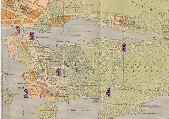
Here are a few landmarks on the 1944 Stockholm map:
- Skansen – the outdoor museum
- Gröna Lund – amusement park and concert stage, right on the water
- Djurgårdsbron – The Djurgården Bridge from from Strandvägen
- Oakhill Palace
- Nordiska Museet (The Nordic Museum) – was associated with Skansen during WWII with exhibits showing Scandinavian living conditions and culture in the past. Royal Armoury with arms, banners, costumes, carriages of historical interest.
- Rosendal – a royal villa built by Charles XIV, with orangeries and hot houses. In 1907, it became a museum.
You can see a small part of Norra Djurgården (Northern Djurgården,) the area north of Djurgårdsbrunnsviken.
Transportation to the island was over the bridge, by taxi/auto, walking or tram. There were also steam launches which crossed over every ten minutes. Because gasoline was so scarce during the war so were private automobiles.


No Comments